Trajectory data refers to the continuous spatiotemporal information obtained by sampling the motion process of one or more moving objects, which generally includes information such as location, time, and speed. In the field of transportation, high-fidelity vehicle trajectory data can play a great role.
However, there are some problems with the existing dataset recorded in continuous traffic flow facilities, which may impede the improvement of traffic safety and efficiency on expressways or highways: 1) For the traffic state, these datasets mainly record data on the state of congestion, and lack of states such as smooth, congestion formation, congestion, and congestion dissipation; 2) Road sections with different segment types have different driving behavior or traffic flow characteristics, but the datasets mainly record on the basic area or merging area of the expressway or interstate highway, and lacks other types of road segment such as weaving area and diverging area; 3) Most of the vehicle trajectory datasets are collected in Europe and the United States, there is a lack of trajectory datasets that record the driving style of Asian drivers.
To solve the three problems raised above, we proposed a detailed plan for unmanned aerial vehicle (UAV) group photography and carried out an experiment on a continuous expressway section with multiple section types in Shanghai, China, and the experiment time was set in and around the morning peak hour. Then, we used state-of-the-art computer vision algorithms to extract the trajectory dataset called MAGIC Dataset (Multiple Conditions UAV Group-based High-fidelity Comprehensive Vehicle Trajectory Dataset).
Road Condition: The experimental field was selected on the Shanghai Inner Ring, i.e., from 1655 Jiaotong Road to the Republican Xin Road Interchange, which has a total length of four-kilometer in both directions and includes a large radius curve and six ramps. The widest part of the main road is three-lane of one direction, and the narrowest part is two-lane of one direction.
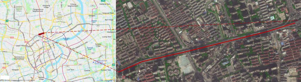
Experimental Field
Among them, the direction of upward traffic flow is from right to left, and the direction of downward traffic flow is from left to right. Furthermore, the upward and downward road sections can be divided into 9 sections respectively, of which 6, 7,8 and 15, 16, 17 are interweaving areas, and the 2, 6, 15, and 17 road sections have changes in the number of lanes.
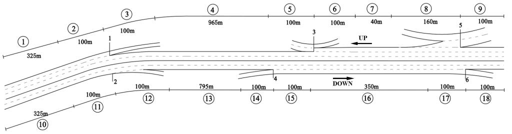
Road Section Division
Recording Time: From 7:40 to 10:40 am on December 21, 2020, covering a morning peak hour.
Video Condition: We conducted the experiment using DJI Mavic 2 Pro, recording at 25 frames per second (FPS) at 4K (4096×2160) resolution. There were a total of six hovering points and three takeoff and landing points to meet the demand for aerial photography. The distance between adjacent hovering points was about 400 meters, and the distance between adjacent takeoff and landing points was about 700 meters. Six UAVs took aerial photographs at six hovering points simultaneously. The recording process is three hours of continuous video capture.
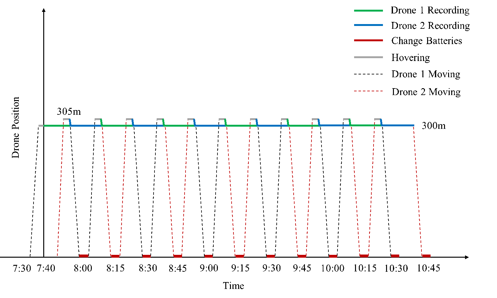
Recording Process of UAVs for Each Hovering Point
Traffic Condition: The MAGIC dataset was evaluated from the three aspects of traffic congestion state, fundamental diagram, and traffic conflict. It can be found that from the perspective of congestion state, this dataset presents different traffic states during the whole observation and the whole process can be roughly divided into three stages. In each stage, the traffic states of upward and downward traffic flow are different.
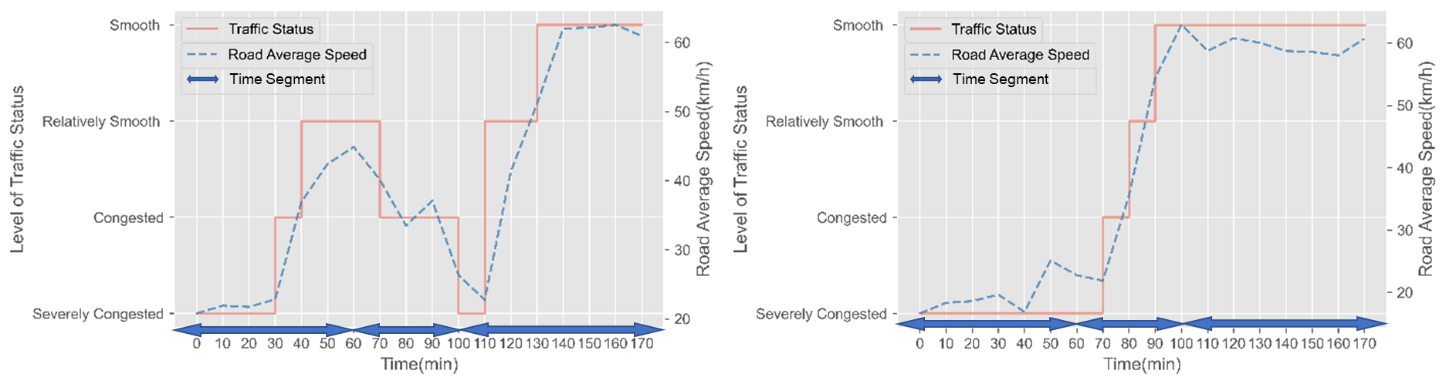
Upward Traffic flow Downward Traffic flow
From the perspective of the fundamental diagram, there are different levels of traffic flow key parameters for road sections with different segments types recorded in the dataset.
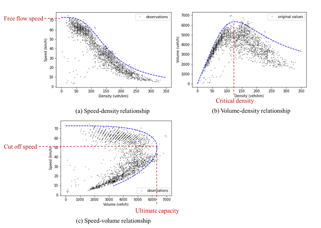
Fundamental Diagrams
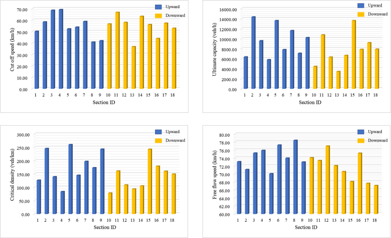
Key Parameters of Each Road Section
From the perspective of traffic conflict, there are significant differences in traffic safety characteristics between road sections with different segment types or traffic states.
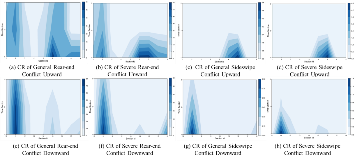
Conflict Rate of Four Types of Conflicts of Each Road Section in Each Traffic State
Data Information: This dataset is extracted by DataFromSky software which provides the precise vehicle position coordinates with a time accuracy of 0.04s, and contains the information of each vehicle’s ID, speed, tangential acceleration, lateral acceleration, lane, and type, etc.
Researchers can select the samples from the MAGIC dataset according to their needs, what’s more, the MAGIC dataset can play a unique role in the differences in spatiotemporal segments and the state evolution processes between spatiotemporal segments, but is not limited to these.
1) Differences in spatiotemporal segments: From the macro perspective, the MAGIC dataset is collected in East Asia, which has a regional difference compared with the well-known dataset collected in the Americas and Europe. There may be some differences in driving habits or traffic flow characteristics, etc. From the micro perspective, samples with different segment types or traffic states in the MAGIC dataset can be used to calibrate different vehicle driving behavior models or traffic flow models. Further, the trajectories in the samples can be regarded as the ones of connected vehicles to design driving assistance strategies under different penetration rates to meet different levels of safety or efficiency requirements, which will greatly increase the speed of autonomous driving or assistance driving development.
2) State evolution processes between spatiotemporal segments: The first application focuses only on the differences between different states, but it can be extended further to the evolution process of different states. For example, the analyses of the formation and dissipation of traffic congestion in time and the spatial propagation of traffic conflicts in space can be realized based on the samples in the dataset. Similarly, this dataset can be used to calibrate the simulation environment for transition mode designing between different levels of driving assistance in connected and autonomous vehicles.
More detailed information can be found in our paper: MAGIC Dataset: Multiple Conditions UAV Group-based High-fidelity Comprehensive Vehicle Trajectory Dataset. To reference the dataset, please cite this publication.
To apply for access to the dataset, please send us a request using this form in the Application Format. The email is MAGICDATASET@163.com. Please make sure that that your answers are complete, detailed, and correct because each request is checked manually. If any ambiguities arise, we may contact you for clarification purposes.
The MAGIC dataset is only free for non-commercial use. If you are interested in commercial use, please contact us via: MAGICDATASET@163.com.
Item |
Content |
Full name |
xxx |
Organization |
xxx |
Organization type |
xxx |
Occupation |
xxx |
Official email address |
xxx |
How do you know the MAGIC dataset? |
xxx |
Purpose or plan to use the MAGIC dataset, including your current research or project, and how you would like to use the MAGIC dataset, etc. |
xxx |
I confirm that the intended use is permitted and non-commercial according to these. |
Yes/No |
Telephone:021-59980132
Email:2410194@tongji.edu.cn,2431730@tongji.edu.cn
Address: Tongda Building, No. 4800, Cao'an Road, Jiading District, Shanghai, China
Postcode:201804

@TONGJI MAGIC All rights reserved